
Install Steam
login
|
language
简体中文 (Simplified Chinese)
繁體中文 (Traditional Chinese)
日本語 (Japanese)
한국어 (Korean)
ไทย (Thai)
Български (Bulgarian)
Čeština (Czech)
Dansk (Danish)
Deutsch (German)
Español - España (Spanish - Spain)
Español - Latinoamérica (Spanish - Latin America)
Ελληνικά (Greek)
Français (French)
Italiano (Italian)
Bahasa Indonesia (Indonesian)
Magyar (Hungarian)
Nederlands (Dutch)
Norsk (Norwegian)
Polski (Polish)
Português (Portuguese - Portugal)
Português - Brasil (Portuguese - Brazil)
Română (Romanian)
Русский (Russian)
Suomi (Finnish)
Svenska (Swedish)
Türkçe (Turkish)
Tiếng Việt (Vietnamese)
Українська (Ukrainian)
Report a translation problem


 2
2 


At the end of the description you will find a hint on how to switch on the icons.
Die Map startet im Jahr 1850. Es sind nur die wenigen Straßentypen verlegt, die im Map-Editor für dieses Jahr angeboten werden. Daher liegt es wahrscheinlich an einem Mod. Es gibt von WernerK ein Tool, mit dem man Straßen löschen kann - vielleicht funktioniert es damit.
Ich wünsche dir viel Freude mit der Map.
You're welcome. Have fun with the map on your new season on YouTube.
You're welcome. Have fun with the map on your new lets play on YouTube.
Many thanks. You're welcome.
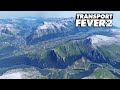
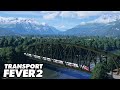
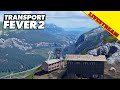
These fine, narrow terrain elevations were automatically generated based on data from Open Street Map. The user of the map can thereby recreate the original routes.